 Search


- The Hong Kong-Zhuhai-Macao Bridge is the most powerful bridge project in the contemporary world
Recently, the Guangdong Provincial Government issued the "Fourteenth Five-Year Development Plan for the Comprehensive Transportation System of Guangdong Province." In order to alleviate the problem of connectivity between the east and the west of the Pearl River, Guangdong will launch a bold super-engineering project, that is, to "study the passage from Shenzhen to Zhuhai and Macau via the Hong Kong-Zhuhai-Macao Bridge to better play the role of the Hong Kong-Zhuhai-Macao Bridge." This means that the world-renowned Hong Kong-Zhuhai-Macao Bridge is expected to be upgraded from the current "Single Y" bridge to the rare "Double Y" bridge.
Previously, the Hong Kong-Zhuhai-Macao Bridge was regarded as the most powerful bridge project in the contemporary world. It has set a number of world records and is the pride of China's bridge industry. All engineers and units who have participated in the construction of the Hong Kong-Zhuhai-Macao Bridge are proud of it.
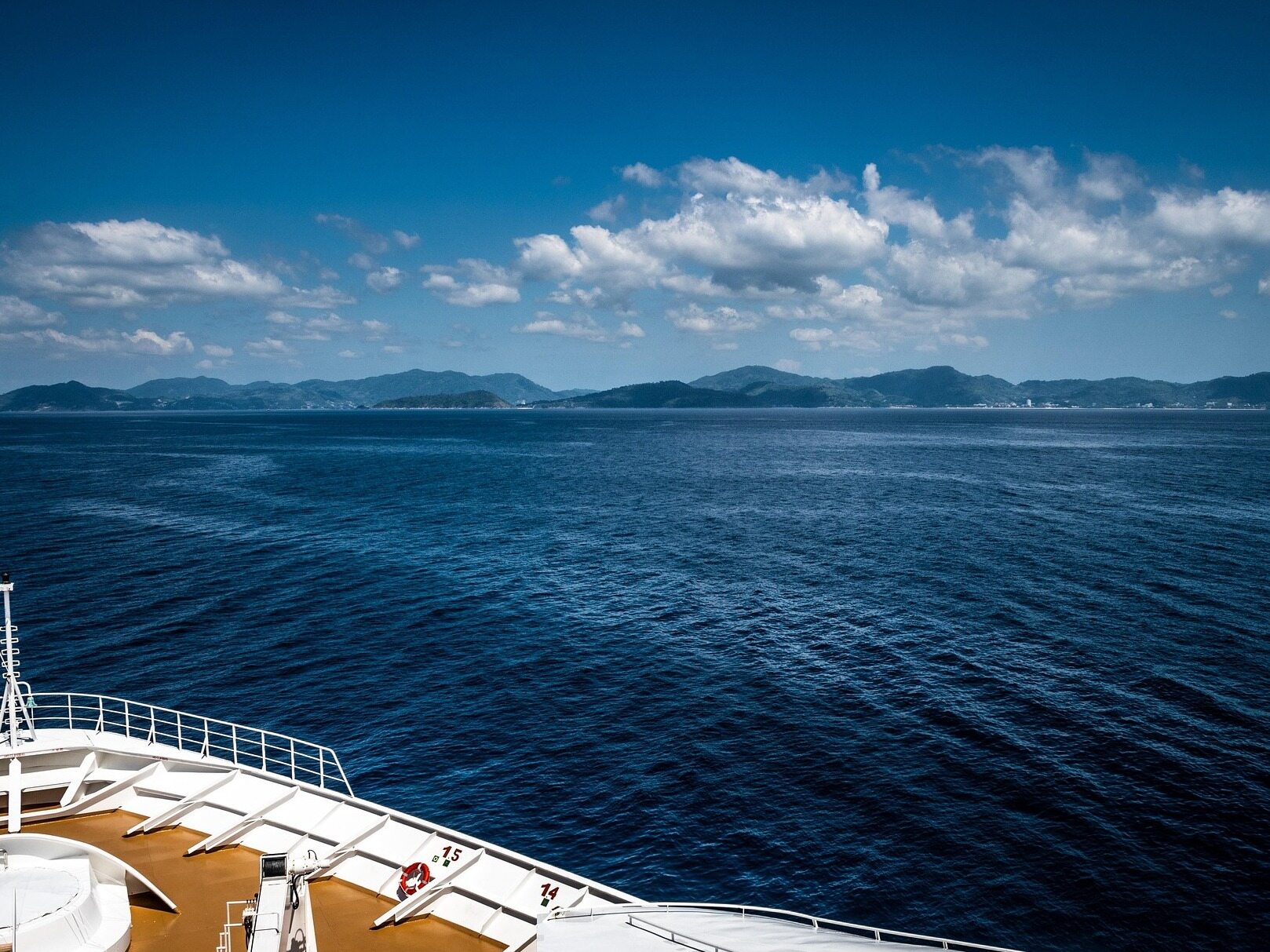
The Hong Kong-Zhuhai-Macao Bridge is located in the Lingdingyang area of Guangdong Province, China. It is the southern ring section of the ring expressway in the Pearl River Delta region, connecting Hong Kong on the east coast with Zhuhai and Macau on the west coast. The Hong Kong-Zhuhai-Macao Bridge integrates bridges, islands and tunnels into one, making it the longest sea-crossing bridge in the world. The total length of the Hong Kong-Zhuhai-Macao Bridge tunnel is 55 kilometers, of which the main bridge is 29.6 kilometers, and the Hong Kong port to the Zhuhai-Macao port is 41.6 kilometers; the submarine tunnel is about 6.75 kilometers long. It is the world's longest road immersed tube tunnel and the only deep buried tunnel. The immersed tube tunnel is also the first offshore immersed tube tunnel in China. The deck of the Hong Kong-Zhuhai-Macao Bridge is a two-way six-lane expressway with a design speed of 100 km/h.
The construction of the Hong Kong-Zhuhai-Macao Bridge took 14 years from design to its official opening to traffic. The major milestones of the construction period were: December 15, 2009, the Hong Kong-Zhuhai-Macao Bridge officially started construction; May 15, 2011, the first steel cylinder went smoothly Launched; On December 7, 2011, a 100,000-square-meter artificial island surfaced; On June 2, 2016, the "Dolphin Tower" was successfully installed; July 7, 2017, the main project of the Hong Kong-Zhuhai-Macao Bridge was completed; 2018 New Year's Day The night before, the main works of the Hong Kong-Zhuhai-Macao Bridge were all lit, and the bridge was ready for traffic; on October 23, 2018, the Hong Kong-Zhuhai-Macao Bridge was officially opened to traffic.
As of now, the Hong Kong-Zhuhai-Macau Bridge is the world’s longest cross-sea bridge with the longest mileage, the longest service life, the largest steel structure, the most difficult construction, the longest immersed tube tunnel, the highest technical content, scientific patents and the largest amount of investment in the world; The technology and equipment scale have created many world records.
The total investment of the Hong Kong-Zhuhai-Macao Bridge project is 126.9 billion yuan. This channel, with a total cost of more than 100 billion yuan, has been under the pressure of insufficient utilization since it opened to traffic.

According to relevant data, in the first more than 100 days of the Hong Kong-Zhuhai-Macao Bridge officially opened to traffic, there were only 100,000 vehicles in and out of Zhuhai Port, which is equivalent to only 1,000 vehicles entering and leaving every day. And the number of vehicles coming in and going out of Macau port is about this many every day. In other words, on average, only more than 2,000 vehicles pass by the Hong Kong-Zhuhai-Macao Bridge every day.
Statistics on October 23, 2019 show that the Hong Kong-Zhuhai-Macao Bridge opened its first anniversary. The total traffic flow of toll gates through the Hong Kong-Zhuhai-Macao Bridge to and from the three ports was 1.5372 million vehicles, an average of about 4,212 vehicles per day. Since then, the daily traffic flow of the Hong Kong-Zhuhai-Macao Bridge has been around 4000 times.
In this way, from the perspective of traffic flow, the utilization rate of this world-renowned super project is indeed not high. Compared with the Humen Bridge and Nansha Bridge, which are relatively close, the traffic flow of the Hong Kong-Zhuhai-Macao Bridge is even more different.
Previously, the traffic flow of Humen Bridge was more than 100,000 vehicles almost every day, and the traffic flow during the peak of the Spring Festival even reached more than 160,000 vehicles a day, with the highest daily average of 170,000 standard vehicles. In other words, the flow of the Humen Bridge in one day exceeds the 100 days of the Hong Kong-Zhuhai-Macao Bridge.
On the Nansha Bridge (Humen Second Bridge), which opened to traffic on April 2, 2019, the total traffic volume in the first 24 hours on the first day of opening to traffic was 54620. On the same day, the traffic volume of Humen Bridge on April 2 still reached 127,000. As of August 2nd to September 2nd, 2019, the average daily traffic flow of Nansha Bridge has reached 120,000 vehicles. On the day of "May 1st" in 2020, the traffic volume of Humen Bridge was about 106,100 vehicles, and the traffic volume of Nansha Bridge was about 205,800 vehicles. Therefore, the Hong Kong-Zhuhai-Macao Bridge is really a world of difference from Humen Bridge and Nansha Bridge.
So why is the traffic flow of the Hong Kong-Zhuhai-Macao Bridge so low? The reason for the insufficient utilization is that only approved license plates of the two places can pass on the Zhuhai-Macao Bridge. The number of vehicles that meet the requirements is tens of thousands in total. It is impossible for these vehicles with access rights to run on the bridge every day. Therefore, it is not surprising that the Hong Kong-Zhuhai-Macao Bridge only has a daily traffic flow of about 4,000.
On the other hand, although the Hong Kong-Zhuhai-Macao Bridge connects Zhuhai and Macau, there is no need to cross the bridge from Zhuhai to Macau, and there are not many people from Zhuhai to Hong Kong. Due to the "single Y plan" adopted, Shenzhen, the largest city in the Guangdong-Hong Kong-Macao Greater Bay Area, has no connecting line to connect to the Hong Kong-Zhuhai-Macao Bridge.
Therefore, residents of Zhuhai and Shenzhen, who are on both sides of the Pearl River, actually very much hope to achieve a direct connection through the Hong Kong-Zhuhai-Macao Bridge. This is also the biggest motivation for the "Double Y Plan".
At present, on the one hand, the utilization rate of the Hong Kong-Zhuhai-Macao Bridge is not high. On the other hand, the number of cars in Shenzhen is even more than twice that of "Hong Kong + Macau + Zhuhai"! Even the car ownership in Dongguan is basically twice that of "Hong Kong + Macau + Zhuhai". The 7 million cars in Shenzhen + Dongguan cannot use the Hong Kong-Zhuhai-Macao Bridge because they do not have licenses in the two places and have no access to the bridge. On the other hand, Zhongshan and Zhuhai, on the west bank of the Pearl River Estuary, watched Shenzhen’s abundant spillover resources flow to Dongguan, Huizhou, and Shanwei, and it was difficult to "share a piece"-the Humen Bridge was too congested, and the Nansha Bridge was too far away. It will take 2 years for the deep-medium channel to be used. Therefore, the transformation of the "Double Y Plan" on the Hong Kong-Zhuhai-Macao Bridge has been called for by people from all walks of life from time to time.
Recently, the "Fourteenth Five-Year Development Plan for the Comprehensive Transportation System in Guangdong Province" re-recommended the study of the "Double Y" plan, hoping that through the construction of the Shenzhen connection line, Shenzhen will be connected to the Hong Kong-Zhuhai-Macao Bridge, so that there are at least nearly 4 million Shenzhen vehicles. Cars can go directly to Zhuhai through the Shekou Peninsula-Bridge Connection Line-Hong Kong-Zhuhai-Macao Bridge. In this way, the extremely deserted Hong Kong-Zhuhai-Macao Bridge can play a role, and resources will not be idle.

It is reported that the general plan is to start from the Shekou Peninsula in Shenzhen, catch the northwestern part of Tuen Mun in Hong Kong, and then use two small islands as a springboard to achieve connectivity on the artificial island on the east side of the Hong Kong-Zhuhai-Macao Bridge. Most of the entire connection line is constructed in the way of tunnels to avoid affecting Hong Kong's waterways and airport operations. The length of the connection line is about 20 kilometers. In this way, the total length from Shenzhen to Zhuhai is estimated to be about 56 kilometers.
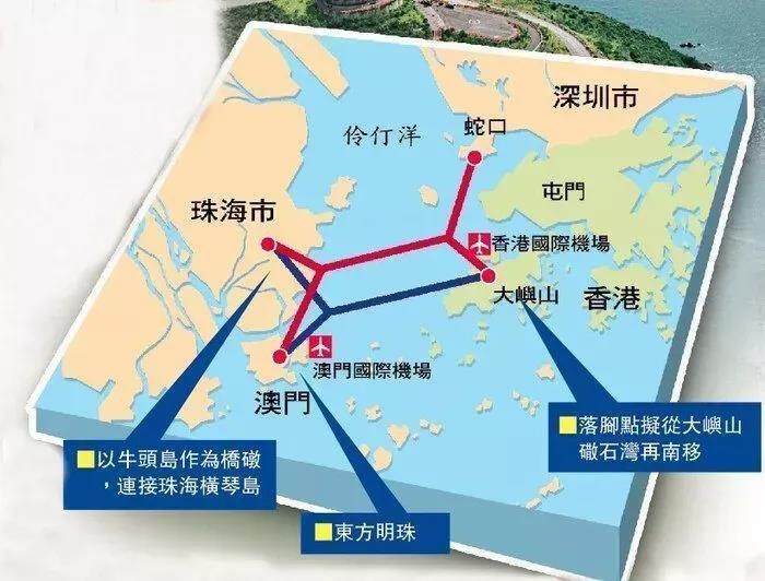
In fact, before the construction of the Hong Kong-Zhuhai-Macao Bridge, there was a fierce dispute between the "Single Y Plan" and the "Double Y Plan". The blue line in the figure below is the "single Y plan" connecting the three cities of Hong Kong, Zhuhai and Macau, and the red line is the "double Y plan" connecting the four cities of Hong Kong, Shenzhen, Zhuhai and Macau. In the end, the construction of the bridge chose the "Single Y Plan" of "no play with Shenzhen".
There are various opinions on why the "double Y plan" was not adopted in the first place. Some said it was due to the high cost of the double-Y scheme, while others said it was due to the low positioning of Shenzhen at that time and the lack of voice.
The total investment of the "Single Y Plan" for the Hong Kong-Zhuhai-Macau Bridge exceeds 100 billion yuan, and the total investment in the "Double Y Plan" is up to 20 billion yuan. This is true for projects with a total investment of 126.9 billion yuan. does not matter. Not to mention that Shenzhen's financial resources are not generally strong. Therefore, investment is definitely not the main reason for adopting the "single Y plan". As for the lack of voice in Shenzhen, this reason is not the real main reason. The real reason should have other profound meanings.
The cross-border management problem may be an important reason why the Hong Kong-Zhuhai-Macao Bridge did not adopt the "Double Y Plan". We know that Shenzhen and Zhuhai are inland cities. Hong Kong and Macau are special administrative regions. In other words, the transportation from Shenzhen to Zhuhai is no different from the other two cities in the mainland. The traffic between inland cities and special administrative regions is cross-border traffic, which is of the nature of entry and exit and requires strict customs clearance. The Hong Kong-Zhuhai-Macao Bridge is actually a large-scale cross-border transportation infrastructure.
The advantage of adopting the "Single Y Plan" for the Hong Kong-Zhuhai-Macao Bridge is that vehicles travelling on the bridge from Hong Kong, Macau, or Zhuhai will go through customs clearance procedures when they get on the bridge and enter customs clearance when they arrive at the underground bridge. There are no exceptions, so implementation is very simple. However, once it is changed to the "Double Y Plan", the largest proportion of vehicles on the Hong Kong-Zhuhai-Macao Bridge must be tens of thousands or even hundreds of thousands of vehicles from Shenzhen to Zhuhai or Zhuhai to Shenzhen. This part of the vehicles accounted for It should exceed 90%.
Obviously, this part of the vehicles that simply pass between Shenzhen and Zhuhai does not require and difficult to go through customs clearance procedures. Because Shenzhen and Zhuhai are both inland cities, and the number of vehicles passing through is too large. However, the vehicles from Shenzhen to Zhuhai are mixed with the vehicles from Hong Kong to Zhuhai and Shenzhen to Macau on the Hong Kong-Zhuhai-Macao Bridge. Similarly, the vehicles from Zhuhai to Shenzhen are also mixed with the vehicles from Macau to Shenzhen and Macau to Hong Kong on the Hong Kong-Zhuhai-Macao Bridge. And this kind of mixed driving is more than 50 kilometers.
Then, here comes the problem. How to distinguish these tens of thousands of mixed vehicles? How to pass the customs for vehicles passing between the four places? How to prevent the change of cars, people, and things on the Hong Kong-Zhuhai-Macao Bridge? and many more.
Thinking about it, it is really a very complicated problem. Solving this problem really requires wisdom. When will the Hong Kong-Zhuhai-Macao Bridge start to implement the "Double Y Plan" transformation, to a large extent depends on whether a reasonable solution to this problem can be found. Do you have any good ideas? Editor/Sang Xiaomei
Comment
 Praise
 Collect
 Comment

 Share
Share


Write something~